Sold20212 Framed Alain Manesson Maps - Scotland & Ceylon, 1683**Originally Listed At $200** Cartographer Alain Manesson Mallet (French, 1630-1706)."Royaume D'Ecosse" (Scotland) AND "Isle de Ceylan" (Sri Lanka, formerly Ceylon). Published in Allain M. Mallet's "DSee Sold Price
Sold2016Coronelli (Vincenzo Maria) - Scotia, Partethe separately titled north and south maps of Scotland joined to form one, decorative title cartouches to each right side, engraved map on 2 sheets, joined, 895 x 630mm., faint central vertical fold,See Sold Price
Sold2017Thomas Kitchin, Maryland and Scotland maps(Scottish, 1718-1784)., "Map of Maryland with the Delaware counties and the southern part of New Jersey," hand colored map, circa 1750, 7 x 9 in. , framed and "Scotland," circa 1760, 7 1/2 x 9 in. , fSee Sold Price
Sold2022Thomson, John The Atlas of ScotlandThomson, John The Atlas of Scotland Edinburgh: for John Thomson & Co., 1832. Large folio (54 x 41cm), contemporary half calf, [4] viii 18, engraved 'Index Map' hand-coloured in outline, 2 engraved plaSee Sold Price
Sold2022Scotland.- Blome (Richard) A Mapp of the Kingdome of Scotland, engraved map with hand-colouring,Scotland.- Blome (Richard) A Mapp of the Kingdome of Scotland, engraving, an excellent impression with full hand-colouring, on laid paper with watermark of bunch of grapes, sheet 390 x 407 mm (15 1/2See Sold Price
Sold2017Jansson: Antique Map of Scotland, 1646Map: 1646 Jansson Map of Scotland -- Provincae Lauden seu Lothien et Linlitouo Cartographer: J. Jansson / Valk & Schenk Year / Place: 1646 c Map Dimensions: 14.2 x 21 in. Condition: Excellent, near fiSee Sold Price
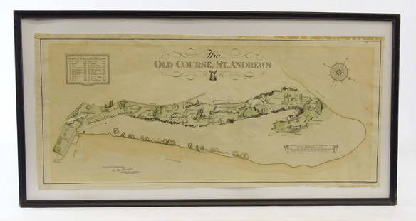
Sold2019Scotland Early Golf MapOld Course St. Andrews Map. Surveyed by A. MacKenize Architect, 1924. McCorquodale & Co., Glasgow, C. 1924. Sight 10 3/4" x 24 1/2".See Sold Price
Sold2022Antiquities Scotland Grose w/ folding color mapHeading: Author: Grose, Francis Title: The Antiquities of Scotland Place Published: London Publisher:Printed for S. Hooper Date Published: 1789; 1791 Description: 2 volumes. xxiSee Sold Price
Sold2020Antique Picot & Co map of England and WalesAntique Picot & Co framed map of England and Wales with part of Scotland. Overall size 37"h x 31"w overall. Paper sight size 27 1/2"h x 21 1/4"w. Published by Picot & Co London and Manchester.See Sold Price
Sold2020Angliae, Scotiae, Et Hiberniae MapCirca 1575; hand colored map of England and Scotland by Abraham Ortelius (1527-1598), 19 x 13 1/2 in., framed.See Sold Price
Sold2024Willen Janszoon Blaeu, Scotia Regnum(Dutch, 1571-1638) Hand colored engraved map of Scotland, c. 1642. Framed double sided with book text on verso. Sight: 16-1/2"h x 21-1/4"w Overall: 26"h x 30-3/4"w Provenance: Paulus Swaen, Inc. IndiaSee Sold Price
Sold2022England & Wales.- Bingley (James) The OfficialNO RESERVE England & Wales.- Bingley (James) The Official Travelling Map of England and Wales with part of Scotland, engraving with original hand-colouring, 595 x 485 mm (23 1/2 x 19 in), dissected anSee Sold Price
Sold20212 Maps Goshen and Litchfield E.M. Woodbridge 18522 Maps Goshen and Litchfield E.M. Woodbridge 1852 41"x32", 51"x41"See Sold Price
Sold202226 books & 2 maps on Santa Barbara CaliforniaA grouping of 26 books and 2 maps pertaining to Santa Barbara CaliforniaLot includes: Spaulding, Edward Selden, Adobe Days Among the Channel, Signed Limited Edition of 1015 copies. Privately printed,See Sold Price
Sold2020Grp: 2 Maps of San Francisco U.S. Coast SurveyTwo maps of San Francisco, California, by the U.S. Coast Survey, featuring a high level of topographical and hydrographical detail. SKU: 03479See Sold Price
Sold20242 Maps CT and RI & General Grant's Long Island2 18th / 19th century maps. H. Harris Rhode Island & Connecticut, hand colored, circa 1802, Thomas and Andrews, 8" x 13 1/2" (with frame 16" x 20 3/4"); Charles Stedman & William Faden Sketch of GenerSee Sold Price
Sold2024Linn, [Lewis F.]. [Oregon Occupation]. In The Senate of the United States. June 6, 1838. With 2 mapsLinn, [Lewis F.]. [Oregon Occupation]. In The Senate of the United States. June 6, 1838. With 2 maps as issued. Provenance: Estate of Meri Jaye, a renowned maritime collector and interior designer ofSee Sold Price
Sold20221872 RR maps of Calif/Nevada – set of 2 mapsScarce lithographs with original hand coloring. Maps show the states of California and Nevada divided into two separate sheets. These very interesting cartographic treasures focus on the developing raSee Sold Price
Sold20162 Maps incl: Scull and Heap. A MAP OF PHILADELPHIA[United States] 2 Maps. ++ N. Scull and G. Heap. A MAP OF PHILADELPHIA And Parts Adjacent. From the folding map’s 2nd appearance in Gentleman’s Magazine [Lon: Dec. 1777], without the table of distSee Sold Price
Sold20202 Maps of Spain2 Maps of Spain. 1). Ortelius (Abraham)-c ''Valentiae Regnieastern Spain''- showing Valencia, large ornamental cartouche and galleons in full sail, engraved map, ca. 1585. 13 3/4 x 19 1/2'' 2). BleauSee Sold Price
Sold2022Napoleon invades Russia, with 2 maps, 1815Heading: Author: Porter, Robert Ker Title: Narrative of the Campaign in Russia During the Year 1812... to which is added A Narrative of the Events Which Followed Buonaparte's Campaign in Russia to thSee Sold Price
Sold202218th C. MAPS OF NORTH AMERICA & CARIBBEAN (2 MAPS)Includes: Brian de la Tour, Louis. L'AMERIQUE DRESSEE POUR L'ETUDE DE LA GEOGRAPHIE (Paris, 1764).Copperplate engraved map of North and South America. Hand colored. Matted and framed. H. 11", W. 12" BSee Sold Price
Sold20182 Maps: Stato Del Gran Turco + Asia Minoris.[De Rossi/Middle East] 2 Maps. ++ Stato Del Gran Turco diviso ne suoi Beglierbati, o Governi, e ne Principati, che li sono Tributari. Elaborate map of the Middle East, including Greece, Italy, the CasSee Sold Price
Sold2017Hand Colored 'Edenburg, Scotland' MapHand Colored 'Edenburg, Scotland' Map c.1640, Amsterdam, a new description of the shyres Lothian and Linlitqvo, mapmaker Timothy Pont, printer Henricus Hondius Height: 14.00 inches, Width: 21.00 incheSee Sold Price
Jun 12Dan Morphy AuctionsLOT OF 2 MAPS: LANDS IN THE COUNTIES OF RUNNELS & TOM GREEN RUNNELS COUNTY TEXAS MAPS.$200
May 30NY Elizabeth 1792 OLD INDIA HISTORY ANTIQUE ILLUSTRATED WITH MAPS OF THE EIGHTEENTH CENTURY IN FRENCH$50
Jun 06Austin Auction Gallery(5) PAUL YSART (ATTRIB.) MILLEFIORI & LAMPWORKED ART GLASS PAPERWEIGHTS$175(2 bids)
Jun 06Austin Auction Gallery(5) PAUL YSART (1904-1991) ART GLASS FLOWER LAMPWORK PAPERWEIGHTS$150(1 bid)
May 30Forum AuctionsItaly.- Rizzi-Zannoni (Giovanni Antonio) [Atlante Geografico del Regno di Napoli], c.1788-1812£500
3 days LeftForum AuctionsChina.- Audemard (L.) Les Jonques Chinoises, vol. I-VI (of X), first edition, 1957-65; and 12 others£50
3 days LeftForum AuctionsRussia.- Peter the Great.- Uystryalov (Nikolai) Karty, Plany I Snimki K Pervym Trem Tomam£750


![Thomson, John The Atlas of Scotland: Thomson, John The Atlas of Scotland Edinburgh: for John Thomson & Co., 1832. Large folio (54 x 41cm), contemporary half calf, [4] viii 18, engraved 'Index Map' hand-coloured in outline, 2 engraved pla](https://p1.liveauctioneers.com/94/251108/130828922_1_x.jpg?height=310&quality=70&version=1655281539)


![Linn, [Lewis F.]. [Oregon Occupation]. In The Senate of the United States. June 6, 1838. With 2 maps: Linn, [Lewis F.]. [Oregon Occupation]. In The Senate of the United States. June 6, 1838. With 2 maps as issued. Provenance: Estate of Meri Jaye, a renowned maritime collector and interior designer of](https://p1.liveauctioneers.com/306/325895/175463708_1_x.jpg?height=310&quality=70&version=1712801883)

![2 Maps incl: Scull and Heap. A MAP OF PHILADELPHIA: [United States] 2 Maps. ++ N. Scull and G. Heap. A MAP OF PHILADELPHIA And Parts Adjacent. From the folding map’s 2nd appearance in Gentleman’s Magazine [Lon: Dec. 1777], without the table of dist](https://p1.liveauctioneers.com/179/85723/44108001_1_x.jpg?height=310&quality=70&version=1457209333)


![2 Maps: Stato Del Gran Turco + Asia Minoris.: [De Rossi/Middle East] 2 Maps. ++ Stato Del Gran Turco diviso ne suoi Beglierbati, o Governi, e ne Principati, che li sono Tributari. Elaborate map of the Middle East, including Greece, Italy, the Cas](https://p1.liveauctioneers.com/179/117971/60557726_1_x.jpg?height=310&quality=70&version=1520636872)


![English Medieval Coins - Mixed Cut AR Halfpenny Group [4] (1 of 1)](https://p1.liveauctioneers.com/1191/327727/176560147_1_x.jpg?height=282&quality=70&version=1714130530)
![Italy.- Rizzi-Zannoni (Giovanni Antonio) [Atlante Geografico del Regno di Napoli], c.1788-1812 (1 of 2)](https://p1.liveauctioneers.com/5458/329231/177514979_1_x.jpg?height=282&quality=70&version=1715269091)


