Sold2024Balkan Peninsula. Turkish Empire. East Rumelia Greece Servia. THE TIMES 1895 mapTITLE/CONTENT OF MAP: 'The Balkan Peninsula' DATE PRINTED: 1895 IMAGE SIZE: Approx 54.0 x 42.0cm, 21.25 x 16.5 inches (Large); Please note that this is a folding map. TYPE: Antique colour atlas map COSee Sold Price
Sold2019The Times 1895 Lot of 7 Maps of EuropeIncl Constantinople, Religions of Europe, Ethnographic Map of the Balkan Peninsula, Greece, Southern Scandinavia, Mediterranean Sea, and General Map of the Alps. Lithograph Maps Published 1895, LondonSee Sold Price
Sold2019OTTOMAN EMPIRE in Europe & Asia. Greece & BritishReserve Reduced! TITLE/CONTENT OF MAP: 'TURKISH EMPIRE IN EUROPE AND ASIA WITH THE KINGDOM OF GREECE' The original 1832 border of the Kingdom of Greece is marked, dividing the Balkan peninsula on a liSee Sold Price
Sold2019The Times 1895 Mixed Lot of 5 European MapsIncl Bohemia/Moravia/Austria Silesia, Wurtemberg/Bavaria, Austrian Alps, Switzerland, and The Balkan Peninsula. Lithograph Maps Published 1895, London for "The Times Atlas" Paper Size: 21 x 16.5 inchSee Sold Price
Sold2019The Times 1895 Pair of Maps. East Indies, Asia"Siam and the Malay Archipelago" and "Burma and the Malay Peninsula" Lithograph Maps Published 1895, London for "The Times Atlas" Paper Size: 16 x 10.5 inch (41 x 27cm) Good ConditionSee Sold Price
Sold2022(OTTOMAN EMPIRE.) Pierre Lapie. Carte Generale de la Turquie d'Europe en XV Feuilles.(OTTOMAN EMPIRE.) Pierre Lapie. Carte Generale de la Turquie d'Europe en XV Feuilles. Enormous engraved map of western Turkey, Greece, and the Balkan Peninsula. 6 parts, approximately 78½x70 inchSee Sold Price
Sold2024Tobias Conrad Lotter Map Of Eastern Mediterranean & Middle EastMagni Turcarum Dominatoris Imperium per Europam, Asiam, et Africam, This striking map covers the Turkish Empire, extending to Greece, Arabia and Libya, with the Caspian and Black Seas and the easternSee Sold Price
Sold2024BALKANS. Wallachia Moldavia Eastern Roumelia N Greece. Railways. LETTS 1883 mapTITLE/CONTENT OF MAP: 'South East Europe - Turkey, Roumania, Servia &c.' DATE PRINTED: 1883 IMAGE SIZE: Approx 36.0 x 42.0cm, 14 x 16.5 inches (Large); Please note that this is a folding map. TYPE: AnSee Sold Price
Sold2016Speed map of Turkish Empire 1626Heading: Author: Speed, John Title: The Turkish Empire. Newly Augmented by Iohn Speed 1626 Place Published: London Publisher:G. Humble Date Published: 1626 Description: CopSee Sold Price
Sold2022TURKISH EMPIRE AND ASIA MINOR SPEED (JOHN) The Turkish Empire, 1676; and 7 other maps of Turkish...TURKISH EMPIRE AND ASIA MINOR SPEED (JOHN) The Turkish Empire, double-page engraved map, 8 city views (including Constantinople, Damascus, Jerusalem and Alexandria) in upper border, 10 costumed figurSee Sold Price
Sold20221627 MIDDLE EAST TRAVELS by G.Sandys antique FOLIO ILLUSTRATED TURKEY HOLY LANDA relation of a iourney begun an: Dom: 1610. Foure bookes. Containing a description of the Turkish Empire, of Aegypt, of the Holy Land, of the remote parts of Italy, and ilands adioyning By Sandys, GeSee Sold Price
Sold2024Antique TC Lotter Magni Turcarum Dominatoris Map19.5 X 22.5 Antique map by famous German cartographer Tobias Conrad Lotter of the Turkish empire, Magni Turcus Dominatoris Imperium. Shows regions of Europe, Asia, and Africa. Original publication donSee Sold Price
Sold202111th C. Byzantine Iron / Bronze Processional Cross**First Time At Auction** Near East, Holy Land, Byzantine Empire, ca. 11th to 13th century CE. A fine processional iron cross with leaded-bronze details. The cross has 4 thick arms presented atop a slSee Sold Price
Sold201818th Century Khmer Stone Buddha HeadCa. 18th century stone Khmer style Buddha head. Styled after artistic techniques prevalent in the time of the powerful Khmer Empire of South East Asia. The Buddha has a peaceful countenance with downcSee Sold Price
Sold2022Middle East.- Saudi Aramco (publisher) Jazirat al-'ArabMiddle East.- Persian Gulf.- Saudi Aramco (publisher) Jazirat al-'Arab wa-al-manatiq al-mutakhimah la-ha: kharitah tamhidiyah [The Arabian Peninsula and neighbouring regions: an introductory map], larSee Sold Price
Sold2022Middle East.- Speed (John) The Kingdome of Persia with the cheef Citties and Habites described,Middle East.- Speed (John) The Kingdome of Persia with the cheef Citties and Habites described, carte-de-figures map of the Persian Empire, with vignettes of Isphan, Hormuz, Tabris, and Tehran along tSee Sold Price
Sold2024Very Interesting Ottoman Turkish Empire Dagger In Excellent Finishing With A Rare Blade In WOOTZVery Interesting Ottoman Turkish Empire Dagger In Excellent Finishing With A Rare Blade In WOOTZ 19th Century, .The Silver Mounts Of The Scabbard Are Designed In Using Ottoman Symbols And Made In ChasSee Sold Price
Sold2024Antique Balkan Greece Enamelled Wedding BeltAntique Balkan Greece Enamelled Wedding Buckle Belt. With gilt filigree wirework decoration and glass cabochons amid blue and green enamel. 30 inches circumference, 5 inches H.See Sold Price
Sold2022(BRITISH EMPIRE.) George Philip & Son, Ltd.; and The London Geographical Institute. Navy League Map(BRITISH EMPIRE.) George Philip & Son, Ltd.; and The London Geographical Institute. Navy League Map of the British Empire. Oversize chromolithograph map of the world delineating early 20th-century BriSee Sold Price
Sold2024Approx. 60 Star Wars ComicsApprox. 60 Dark Horse Star Wars Comics. Titles include Clone Wars; Dark Times; Crimson Empire and more. Average condition VF+.See Sold Price
Sold2023Superb Persian Achaemenid 23K+ Gold Lion Appliques**Originally Listed At $5000** Near East, Iran, Achaemenid Empire, ca. 6th to 4th century BCE. A pair of 99% gold (equivalent to 23K+ to 24K) applique ornaments repousse formed into roaring lion headsSee Sold Price
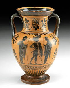
Sold2023Greek Attic Black-Figure Amphora, Light-Make Class**First Time At Auction** Greece, Attic, attributed to the Light-Make Class, ca. 540 to 480 BCE. A splendid pottery neck amphora boasting skillfully painted black-figure decoration of 3 battling warriSee Sold Price
Sold2023Chinese Han Lifan Pottery Amphora w/ Bronze, TL Tested**First Time At Auction** East Asia, Western China, Han Dynasty, ca. 206 BCE to 220 CE. A large pottery vase, the surface burnished to a fine grey hue and inlaid with bronze bosses. Panels of incisedSee Sold Price
Sold2018Signed 17th C. Japanese Tadayoshi Wakizashi & Scabbard**First Time At Auction** East Asia, Japan, early Edo Period, ca. 1615 to 1624 CE, signed by Hashimoto Shinzaemon Tadayoshi (1572-1632 CE). An incredible wakizashi with a single-edged blade, a scabbarSee Sold Price
6 days LeftWorthington GalleriesAntique H/C Map EUROPE SOUS CHARLEMAGNE EN 814: EMPIRES D'OCCIDENT ET D'ORIENT$25
Jun 15Bazaar of PersiaLot of Us 1894 bureau issue unwatermarked and 30 cent Jefferson - black$70(3 bids)
Jun 13DOYLE Auctioneers & AppraisersUniversal Geneve Gold 'Royal Presentation' Watch, Ref. 10 232.7$4,000
Jun 16Palmyra Heritage GalleryAncient Greek, Bronze Phiale Libation Bowl With Inscription c.5th century BC.$125(3 bids)
5 days LeftSimpson Galleries, LLC.JULIUS BIEN (1826-1909) AN AMERICAN CIVIL WAR RECONNAISSANCE MAP, "Map of Texas and Part of New$100
Jun 23Schilb Antiquarian Rare BooksUS War w/ SPAIN 1898 1ed Puerto Rico CUBA Philippines MAPS Russell Illustrated$78(4 bids)


![Middle East.- Saudi Aramco (publisher) Jazirat al-'Arab: Middle East.- Persian Gulf.- Saudi Aramco (publisher) Jazirat al-'Arab wa-al-manatiq al-mutakhimah la-ha: kharitah tamhidiyah [The Arabian Peninsula and neighbouring regions: an introductory map], lar](https://p1.liveauctioneers.com/5458/236692/122702431_1_x.jpg?height=310&quality=70&version=1644332470)


![[MAP]. ORTELIUS, Abraham. Turcici Imperii Descriptio.1592. (1 of 2)](https://p1.liveauctioneers.com/197/329395/177650538_1_x.jpg?height=282&quality=70&version=1715364962)


![[MAP]. ORTELIUS, Abraham. Romani Imperii Imago. 1592. (1 of 2)](https://p1.liveauctioneers.com/197/329395/177650537_1_x.jpg?height=282&quality=70&version=1715364962)


![[MAP]. SPEED, John. A New Mappe of the Romane Empire. 1676. (1 of 2)](https://p1.liveauctioneers.com/197/329395/177650541_1_x.jpg?height=282&quality=70&version=1715364962)


